64.14958043056116
25.296648389060934
Ä04654
https://map.suomenilmakuva.fi/_project/_layout/gfx/red-pin-small.png
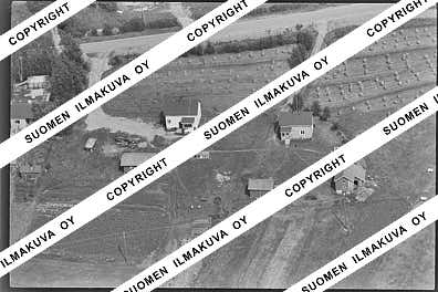
64.1420487446238
25.339565546634777
Ä04654-01
https://map.suomenilmakuva.fi/_project/_layout/gfx/photo.png

64.14301359443499
25.336507935747495
Ä04654-02
https://map.suomenilmakuva.fi/_project/_layout/gfx/photo.png
64.14512531222235
25.329567743420064
Ä04654-03
https://map.suomenilmakuva.fi/_project/_layout/gfx/photo.png

64.14612384625713
25.327896750178127
Ä04654-04
https://map.suomenilmakuva.fi/_project/_layout/gfx/photo.png

64.14779784796765
25.324754951849588
Ä04654-05
https://map.suomenilmakuva.fi/_project/_layout/gfx/photo.png

64.14936254557063
25.311732145909847
Ä04654-06
https://map.suomenilmakuva.fi/_project/_layout/gfx/photo.png

64.14916321968924
25.309273509133078
Ä04654-07
https://map.suomenilmakuva.fi/_project/_layout/gfx/photo.png
64.14904041950952
25.307425362348027
Ä04654-08
https://map.suomenilmakuva.fi/_project/_layout/gfx/photo.png

64.14832274994397
25.305201249983906
Ä04654-09
https://map.suomenilmakuva.fi/_project/_layout/gfx/photo.png

64.14874520365143
25.30338998801314
Ä04654-10
https://map.suomenilmakuva.fi/_project/_layout/gfx/photo.png

64.1486362218737
25.30011002348532
Ä04654-11
https://map.suomenilmakuva.fi/_project/_layout/gfx/photo.png

64.14924275029308
25.298367177563737
Ä04654-12
https://map.suomenilmakuva.fi/_project/_layout/gfx/photo.png

64.14834937757432
25.296710491835736
Ä04654-13
https://map.suomenilmakuva.fi/_project/_layout/gfx/photo.png

64.14956519035448
25.30175717342932
Ä04654-14
https://map.suomenilmakuva.fi/_project/_layout/gfx/photo.png

64.14880105844951
25.28825256667945
Ä04654-15
https://map.suomenilmakuva.fi/_project/_layout/gfx/photo.png

64.14856845958347
25.291388175546086
Ä04654-16
https://map.suomenilmakuva.fi/_project/_layout/gfx/photo.png

64.14878738273731
25.29004996458488
Ä04654-17
https://map.suomenilmakuva.fi/_project/_layout/gfx/photo.png

64.14915696761707
25.278834933584843
Ä04654-18
https://map.suomenilmakuva.fi/_project/_layout/gfx/photo.png

64.14972013591743
25.272982234003425
Ä04654-19
https://map.suomenilmakuva.fi/_project/_layout/gfx/photo.png

64.15026268337299
25.2806569700816
Ä04654-20
https://map.suomenilmakuva.fi/_project/_layout/gfx/photo.png

64.1502362824543
25.27553785632267
Ä04654-21
https://map.suomenilmakuva.fi/_project/_layout/gfx/photo.png

64.14986576034269
25.272865880099275
Ä04654-22
https://map.suomenilmakuva.fi/_project/_layout/gfx/photo.png

64.15145173472662
25.27202052255387
Ä04654-23
https://map.suomenilmakuva.fi/_project/_layout/gfx/photo.png

64.15139971987317
25.25829046394506
Ä04654-24
https://map.suomenilmakuva.fi/_project/_layout/gfx/photo.png

64.15274585669738
25.26304477652696
Ä04654-25
https://map.suomenilmakuva.fi/_project/_layout/gfx/photo.png

64.152770998184
25.262054020168605
Ä04654-26
https://map.suomenilmakuva.fi/_project/_layout/gfx/photo.png

64.15212380448204
25.257293803200643
Ä04654-27
https://map.suomenilmakuva.fi/_project/_layout/gfx/photo.png

64.15020151888002
25.243615547350114
Ä04654-28
https://map.suomenilmakuva.fi/_project/_layout/gfx/photo.png

64.1510828334665
25.246801403748446
Ä04654-29
https://map.suomenilmakuva.fi/_project/_layout/gfx/photo.png

64.15036577681654
25.245121521001817
Ä04654-30
https://map.suomenilmakuva.fi/_project/_layout/gfx/photo.png

64.14993072972241
25.24640103947571
Ä04654-31
https://map.suomenilmakuva.fi/_project/_layout/gfx/photo.png

64.1507658121408
25.23646188551537
Ä04654-32
https://map.suomenilmakuva.fi/_project/_layout/gfx/photo.png

64.15198917701902
25.233168648831217
Ä04654-33
https://map.suomenilmakuva.fi/_project/_layout/gfx/photo.png

64.15265900040356
25.23062906738528
Ä04654-34
https://map.suomenilmakuva.fi/_project/_layout/gfx/photo.png

64.15323195929787
25.228593245329265
Ä04654-35
https://map.suomenilmakuva.fi/_project/_layout/gfx/photo.png

64.15490207358447
25.225028991166813
Ä04654-36
https://map.suomenilmakuva.fi/_project/_layout/gfx/photo.png
