65.93166348611803
27.190672915628806
Ä10285
https://map.suomenilmakuva.fi/_project/_layout/gfx/red-pin-small.png
65.94319
27.26134
Ä10285-01
https://map.suomenilmakuva.fi/_project/_layout/gfx/photo.png
65.94361907105788
27.25252768552731
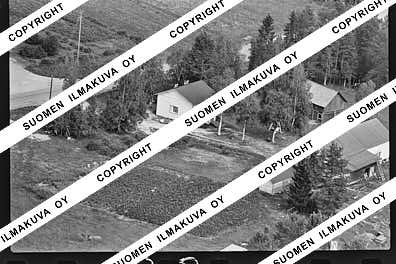
Ä10285-02
https://map.suomenilmakuva.fi/_project/_layout/gfx/photo.png
65.93684863991014
27.219446127633972
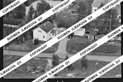
Ä10285-03
https://map.suomenilmakuva.fi/_project/_layout/gfx/photo.png
65.93572215276113
27.2118749640467
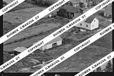
Ä10285-04
https://map.suomenilmakuva.fi/_project/_layout/gfx/photo.png
65.93166574863042
27.204511702146256
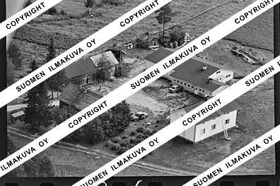
Ä10285-05
https://map.suomenilmakuva.fi/_project/_layout/gfx/photo.png
65.93155275475321
27.204205080110533
Ä10285-06
https://map.suomenilmakuva.fi/_project/_layout/gfx/photo.png
65.93210446715852
27.203299026761346
Ä10285-07
https://map.suomenilmakuva.fi/_project/_layout/gfx/photo.png
65.93453189764367
27.200705812283115
Ä10285-08
https://map.suomenilmakuva.fi/_project/_layout/gfx/photo.png
65.9333549936462
27.202093486943493
Ä10285-09
https://map.suomenilmakuva.fi/_project/_layout/gfx/photo.png
65.93339437049157
27.20230609391744
Ä10285-10
https://map.suomenilmakuva.fi/_project/_layout/gfx/photo.png
65.93432992025707
27.203470296863888
Ä10285-11
https://map.suomenilmakuva.fi/_project/_layout/gfx/photo.png
65.92326357646755
27.18711519392109
Ä10285-12
https://map.suomenilmakuva.fi/_project/_layout/gfx/photo.png
65.92261259630502
27.148525580149954
Ä10285-13
https://map.suomenilmakuva.fi/_project/_layout/gfx/photo.png
65.92162291904565
27.147416457220377
Ä10285-14
https://map.suomenilmakuva.fi/_project/_layout/gfx/photo.png
65.92125721974163
27.141457767590662
Ä10285-15
https://map.suomenilmakuva.fi/_project/_layout/gfx/photo.png
65.92076258269225
27.14322704066687
Ä10285-16
https://map.suomenilmakuva.fi/_project/_layout/gfx/photo.png
65.92054978158127
27.14133900173491
Ä10285-17
https://map.suomenilmakuva.fi/_project/_layout/gfx/photo.png
65.92156401312772
27.1467450366197
Ä10285-18
https://map.suomenilmakuva.fi/_project/_layout/gfx/photo.png
65.92062247008506
27.145494922622298
Ä10285-19
https://map.suomenilmakuva.fi/_project/_layout/gfx/photo.png
65.92076692339103
27.14302464117566
Ä10285-20
https://map.suomenilmakuva.fi/_project/_layout/gfx/photo.png
65.92045175149096
27.14104542462369
Ä10285-21
https://map.suomenilmakuva.fi/_project/_layout/gfx/photo.png
65.92085586905876
27.13954776711976
Ä10285-22
https://map.suomenilmakuva.fi/_project/_layout/gfx/photo.png
65.92139099393631
27.14126173173583
Ä10285-23
https://map.suomenilmakuva.fi/_project/_layout/gfx/photo.png
65.92276123849213
27.147986656240455
Ä10285-24
https://map.suomenilmakuva.fi/_project/_layout/gfx/photo.png
65.92066237156155
27.14572626650267
Ä10285-25
https://map.suomenilmakuva.fi/_project/_layout/gfx/photo.png
65.91999043515538
27.146698923501454
Ä10285-26
https://map.suomenilmakuva.fi/_project/_layout/gfx/photo.png
65.9220234028199
27.15530892608599
Ä10285-27
https://map.suomenilmakuva.fi/_project/_layout/gfx/photo.png
65.92262963032948
27.14821081615896
Ä10285-28
https://map.suomenilmakuva.fi/_project/_layout/gfx/photo.png
65.91730375840972
27.128519847989796
Ä10285-29
https://map.suomenilmakuva.fi/_project/_layout/gfx/photo.png
65.91607133509538
27.12482715863806
Ä10285-30
https://map.suomenilmakuva.fi/_project/_layout/gfx/photo.png
65.91571593146581
27.12277499729324
Ä10285-31
https://map.suomenilmakuva.fi/_project/_layout/gfx/photo.png
65.9172001064143
27.127118206150122
Ä10285-32
https://map.suomenilmakuva.fi/_project/_layout/gfx/photo.png
65.91685862245167
27.128240794441886
Ä10285-33
https://map.suomenilmakuva.fi/_project/_layout/gfx/photo.png
65.91731393338996
27.12183004248444
Ä10285-34
https://map.suomenilmakuva.fi/_project/_layout/gfx/photo.png
65.91735990183285
27.12579336253483
Ä10285-35
https://map.suomenilmakuva.fi/_project/_layout/gfx/photo.png
65.91576276932167
27.12260539154152
Ä10285-36
https://map.suomenilmakuva.fi/_project/_layout/gfx/photo.png


